
Geofencing advertising triggers ads or push notifications the moment a device crosses a virtual boundary, making it the right tactic when you need to influence foot traffic, event attendees, or competitor-adjacent shoppers in real time. Unlike broad digital campaigns, the ROI signal that matters here is visit attribution, not click-through rate. Theartistevolution has run these campaigns across retail, healthcare, and legal sectors, and the pattern is consistent: marketers who measure visits and conversion lift outperform those who optimize for clicks alone.
At a glance, geofencing advertising delivers when you need:
- Immediate, context-driven action (drive-to-store, event engagement, competitor conquest)
- Mobile-first delivery tied to a physical location or boundary event
- Measurable foot-traffic lift validated through visit attribution and conversion zones
- Privacy-compliant targeting that respects CCPA/CPRA and app permission frameworks
Table of Contents
- What is geofencing advertising, and how does it differ from geotargeting?
- How does geofencing actually detect devices?
- What geofence shapes and targeting methods should you use?
- Where does geofencing work best? Real use cases by industry
- How much does geofencing advertising cost?
- How do you set up a geofencing campaign step by step?
- How do you measure geofencing campaign results?
- What are the best practices and common mistakes in geofencing?
- U.S. privacy and compliance rules you need to know
- Should you run geofencing in-house or hire an agency?
- Key Takeaways
- The fence shape is the campaign
- Theartistevolution can run your geofencing campaign from strategy to results
- Useful sources for further reading
What is geofencing advertising, and how does it differ from geotargeting?
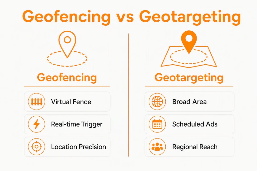
Geofencing advertising uses GPS, Wi-Fi, or cellular signals to define a virtual boundary around a real-world location. When a device enters or exits that boundary, a trigger fires and delivers an ad, push notification, or in-app message. The key word is trigger: geofencing is event-driven, not persistent.
Geotargeting works differently. It serves ads to users based on their general location, often combined with demographic or behavioral data, without requiring a boundary-crossing event. Think of geotargeting as casting a wide net across a zip code or metro area, while geofencing is a trip wire at a specific door.
Geofencing vs. geotargeting at a glance:
- Geofencing: event-driven, boundary-crossing trigger; best for immediate conversions and foot-traffic goals
- Geotargeting: area-based, persistent reach; best for brand awareness and audience scale
- Delivery channels: geofencing primarily runs through in-app push, mobile display, and programmatic tags; geotargeting spans display, search, social, and email
- Audience precision: geofencing captures everyone who crosses the fence; geotargeting can layer demographics, interests, and behaviors on top of location
Geofencing and geotargeting are complementary: use geotargeting to build awareness across a region, then deploy geofencing to convert the most motivated prospects at the moment they are physically close.
How does geofencing actually detect devices?
The technical foundation matters because it directly affects accuracy, audience size, and campaign cost. Most geofencing platforms rely on a combination of four signals.
Primary location signals:
- GPS: the most accurate signal for outdoor environments; communicates with the device’s onboard chip and is standard for most mobile geofencing
- Wi-Fi triangulation: useful in dense urban areas or indoor spaces where GPS weakens; identifies device proximity to known access points
- Cell tower data: lower precision but broader coverage; often used as a fallback or for rural targeting
- Bluetooth beacons: short-range, indoor-grade precision; can pinpoint a user to a specific aisle or exhibit
SDKs embedded in apps collect these signals and pass location events to the ad platform. App permissions are the gating factor: if a user has not granted location access, the device is invisible to the fence. OS-level restrictions on iOS and Android have tightened significantly, which means addressable audiences can be smaller than raw app-install counts suggest. App-store privacy controls and OS permission dialogs can drastically reduce the audience you can reach, so plan engagement strategies that offer a clear value exchange to encourage opt-in.
The event flow from fence to impression:
- A marketer defines the fence geometry and loads it into the platform
- A device with location permissions crosses the boundary
- The platform fires an ad trigger or push notification
- The impression or message is delivered to the device
- The platform logs the event for attribution tie-back
Latency between the crossing event and ad delivery varies by platform and signal type. GPS-triggered fences in open environments tend to fire within seconds; Wi-Fi-dependent fences in dense buildings can lag.
Pro Tip: Before full budget deployment, run a small live test with a handful of devices to validate signal timing and delivery delays at your specific locations. A fence that looks perfect on a map can behave differently in a real retail corridor.
What geofence shapes and targeting methods should you use?
Fence geometry is one of the most consequential decisions in a campaign. The shape you choose affects precision, wasted impressions, and attribution accuracy.

| Geofence Type | Best For | Key Trade-off |
|---|---|---|
| Radius | Quick setup, single-location campaigns | Can include parking lots, neighboring stores, or street traffic |
| Polygon / building footprint | Dense retail, multi-tenant buildings, precise visit attribution | Requires accurate POI data; higher setup effort |
| Isochrone (drive/walk time) | Suburban trade areas, QSR daypart targeting | Road topology complexity; platform support varies |
| Beacon (Bluetooth) | Indoor aisle-level, event activation, museum wayfinding | Requires hardware installation; limited to opted-in app users |
When each method fits:
- Radius geofences work for isolated locations with clear physical separation from competitors, like a standalone gas station or a rural clinic.
- Polygon and building-footprint geofences are the right call for dense or mixed-use environments. Building-footprint geofences exclude off-target areas like parking lots and neighboring stores, reducing wasted spend and false-positive visit counts versus simple radius fences.
- Isochrone geofences map a realistic trade area based on drive or walk time rather than straight-line distance. In suburban markets where a river or highway cuts through a radius, isochrones produce more accurate trade areas and often better cost per acquisition.
- Beacons deliver the highest indoor precision but require hardware and an opted-in app audience, making them best suited for controlled environments like flagship stores or conference venues.
Boundary precision is the most common operational failure in geofencing campaigns. Advanced shapes and building footprints materially improve both campaign efficiency and attribution accuracy.
Where does geofencing work best? Real use cases by industry
The strongest geofencing campaigns share one trait: the objective, the fence type, and the KPI are aligned before the campaign launches.

Retail footfall and drive-to-store remain the dominant use case. A specialty retailer can fence its own building footprint and deliver a time-limited promo code to shoppers who enter, then measure redemption rate and visit lift against a control zone. Pair that with a retail activation strategy and the in-store data becomes a feedback loop for creative optimization.
Events and venue engagement are a natural fit. When a device enters a concert venue or convention center, the organizer can push wayfinding messages, upsell offers, or sponsor activations. Timing is everything here: a message delivered at entry converts far better than one sent an hour later.
Competitor conquesting targets users who enter a rival’s location with a contextual offer. Car dealerships and QSR brands use this regularly. Uber’s airport and hotel geofences are a well-documented example: when passengers exit a terminal, the platform immediately surfaces nearby driver availability. The ethics consideration is straightforward: the message must be genuinely useful, not just disruptive.
Local services and real estate benefit from isochrone-based fences. An open-house alert sent to homebuyers within a 10-minute drive of a listing, timed to a Saturday morning, is far more relevant than a display ad served to a zip code.
The campaign framework that consistently works: define the objective first, then select the fence type that matches the physical reality of the location, then choose the KPI that proves the objective was met. A lunchtime drive-to-store campaign for a QSR brand, for example, uses an isochrone around a business district, targets devices between 11 AM and 1 PM, and measures visit lift against the prior two-week baseline.
Objective-to-KPI mapping examples:
- Increase lunchtime visits → isochrone around business district → KPI: visit lift vs. baseline
- Drive event attendance → building footprint of venue → KPI: dwell time and repeat entry rate
- Competitor conquest → radius around rival location → KPI: conversion rate on promo code
- Open-house traffic → drive-time isochrone from listing → KPI: visit count and inquiry form submissions
Geofencing also integrates well with CTV, mobile display, and out-of-home to increase recall and tie digital touches to physical behaviors, which is why multi-channel programs consistently outperform single-channel geofencing alone.
How much does geofencing advertising cost?
Geofencing campaigns are priced on CPM (cost per thousand impressions) or CPC (cost per click). Pricing is driven by geofence size, audience density, campaign duration, and location-data quality, which means the same budget can produce very different results depending on how the campaign is structured.
CPMs for geofencing tend to run higher than broad display because the audience is smaller and more precisely defined. That is not a flaw; it reflects the higher intent signal of a device that is physically present at a relevant location.
| Cost Driver | Direction of Impact |
|---|---|
| Smaller, denser geofence | Higher CPM (smaller addressable pool) |
| Larger radius or metro-wide fence | Lower CPM, more wasted impressions |
| Premium location-data provider | Higher data cost, better attribution accuracy |
| Dayparting (limited hours) | Reduces total spend, improves relevance |
| Short campaign duration (under 2 weeks) | Higher effective CPM due to setup overhead |
| Building-footprint geometry | Moderate CPM, lower wasted spend |
Platform types and cost shapes:
- Self-serve DSPs: lower management fees, more control, but require in-house ad ops expertise
- Managed agency platforms: higher fees, but strategy, creative, and measurement are included
- SDK/API integrations: highest technical overhead, best for brands with a proprietary app and engineering resources
Campaigns can run via self-serve DSPs, managed agency platforms, or SDK/API integration, each with different control, cost, and implementation timelines. The practical starting point for most mid-market advertisers is a managed platform or agency partner that handles location-data sourcing and attribution setup.
Budgeting guidance:
- Start with a pilot at one or two locations before scaling to a full portfolio
- Daypart to the hours when your audience is most likely to convert, reducing wasted impressions
- Use the pilot CPM and visit CPA to project full-campaign economics before committing budget
How do you set up a geofencing campaign step by step?
A well-structured setup prevents the most common failures: oversized fences, undefined KPIs, and attribution gaps.
- Define the objective and primary KPI. Visits, in-store conversions, app events, or promo code redemptions. Pick one primary metric before touching the platform.
- Select geofence method and map locations. Use building footprints or isochrones when precision matters. Pull POI data from a reliable source and validate fence boundaries against satellite imagery.
- Layer the audience. Exclude obvious passersby (set minimum dwell time thresholds where the platform allows), apply frequency caps to avoid ad fatigue, and layer in CRM match or lookalike segments where available.
- Build creative for immediacy. Geofencing creative needs a clear, time-sensitive CTA: a unique promo code, a deep link to a relevant app screen, or a landing page that confirms the offer. Generic brand ads underperform here.
- Choose a vendor or platform and set bidding rules. Decide between self-serve, managed, or SDK. Set dayparting windows, bid floors, and impression caps before launch.
- Pilot, validate attribution, then scale. Run the campaign at one location for two to four weeks. Establish a pre-campaign baseline for foot traffic, then compare post-launch visit rates. Use a control zone to isolate incremental lift before scaling.
Pre-launch checklist:
- [ ] Objective and KPI documented
- [ ] Fence geometry validated against satellite imagery
- [ ] Audience exclusions and frequency caps set
- [ ] Unique promo codes or tracking URLs in place
- [ ] Attribution window defined (typically 1–7 days post-impression)
- [ ] Control zone or holdout group established
- [ ] Privacy disclosures and consent flows confirmed
- [ ] Baseline foot-traffic data pulled for the prior 2–4 weeks
Pro Tip: Test your fence boundaries at small scale first. Walk or drive the perimeter with a test device to confirm the trigger fires where you expect it to, not 50 meters down the street.
How do you measure geofencing campaign results?
Visit attribution is the metric that separates a well-run geofencing program from one that looks good on a dashboard but does not move the business. High-performing teams track visit attribution or lift studies rather than vanity metrics, and optimize to incremental visits per 1,000 impressions for ROAS clarity.
| KPI | Why It Matters | How to Calculate |
|---|---|---|
| Visit lift | Measures incremental foot traffic driven by the campaign | (Post-campaign visits – baseline visits) / baseline visits |
| Conversion zone rate | Ties impressions to physical store entries | Unique device entries in conversion zone / total impressions |
| Cost per visit (CPV) | Normalizes spend against physical outcomes | Total campaign spend / attributed visits |
| Dwell time | Indicates engagement quality inside the location | Average time a device spends inside the fence post-entry |
| Repeat visit rate | Signals loyalty and campaign stickiness | Devices that return within the attribution window / total attributed visitors |
Attribution methods that work:
- Unique promo codes: the simplest and most portable method; redemption rate is a clean conversion signal
- Device ID matching: the platform matches the device that received the impression to a device observed in the conversion zone
- Lift studies with control zones: a holdout group in a comparable area receives no ads; the visit-rate difference is the incremental lift
- Pre/post baseline comparison: pull foot-traffic data for the same period in prior weeks and compare
Attribution windows for geofencing are typically shorter than for other digital channels. A same-day to seven-day window is standard; longer windows risk crediting the campaign for visits driven by other factors.
Pro Tip: Always define a control zone before launch. A comparable location or geographic area that receives no campaign impressions gives you the cleanest read on whether the campaign actually moved foot traffic or whether people were coming anyway.
What are the best practices and common mistakes in geofencing?
The gap between a geofencing campaign that drives real visits and one that burns budget is usually operational, not strategic.
Best practices:
- Use building footprints or isochrones instead of radius fences in any dense or mixed-use environment
- Daypart to the hours when your audience is most likely to act; a dinner-focused restaurant does not need impressions at 7 AM
- Pair geofencing with CRM or lookalike segments to raise the floor on audience quality
- Write creative for the moment: the message should feel like it belongs right now, at this location
- Document your measurement window and stick to it; changing the attribution window mid-campaign invalidates comparisons
Common mistakes:
- Oversized radii that capture foot traffic from irrelevant areas, inflating visit counts and wasting spend
- Ignoring OS-level location permission limits, which can shrink the addressable audience well below expectations
- Optimizing for CTR instead of visit lift, which rewards clicks from users who never enter the store
- Skipping the control zone, making it impossible to separate campaign-driven visits from organic traffic
- Letting POI and footprint data go stale; a fence built on outdated building data can target the wrong structure
Operational tips:
- Refresh POI and footprint data at least quarterly, especially for retail portfolios with frequent store changes
- Document measurement windows and attribution methodology before launch so results are comparable across campaigns
- Budget for at least one optimization cycle after the pilot; the first two weeks of data almost always reveal a fence or creative adjustment that improves performance
Pro Tip: Define one narrow success metric before launch, such as incremental visits per 1,000 impressions, and optimize every decision to that number. Campaigns with a single clear north-star metric consistently outperform those chasing multiple KPIs simultaneously.
U.S. privacy and compliance rules you need to know
Location data is among the most sensitive categories under U.S. consumer-protection frameworks. Getting this wrong is not just a legal risk; it erodes consumer trust in ways that are hard to recover from.
Core obligations:
- Respect opt-in and opt-out settings at both the app and OS level; never attempt to circumvent permission dialogs
- Be transparent in your privacy policy about what location data you collect, how long you retain it, and who you share it with
- Honor consumer data requests under CCPA/CPRA, including the right to know, delete, and opt out of the sale or sharing of personal information
- Limit data retention to the minimum period necessary for attribution and reporting
Relevant U.S. frameworks:
- CCPA/CPRA: California’s privacy law requires businesses to disclose location data collection, provide opt-out mechanisms, and respond to consumer requests within defined timelines. Even if your business is not based in California, you likely have California users.
- FTC guidance: the FTC has consistently signaled that collecting precise location data without clear consumer notice and meaningful choice is an unfair or deceptive practice. U.S. geofencing campaigns must align with transparency, user choice, and location-data handling consistent with consumer-protection expectations.
- App-store policies: Apple’s App Tracking Transparency framework and Google’s location permission tiers both require explicit user consent for precise location tracking. Non-compliance can result in app removal.
Practical compliance checklist:
- Audit all data flows: know exactly which location signals you collect, where they go, and who processes them
- Record consent at the point of collection; store consent logs with timestamps
- Limit retention: delete raw device-level location data after attribution is complete
- Anonymize or aggregate data before sharing with third parties
- Add clear location-data disclosures to app onboarding screens, landing pages, and privacy policies
- Review your location-data provider’s own compliance posture; their practices become your liability
Theartistevolution builds privacy-aware campaign architectures for U.S. clients by default, including consent flow audits and data-retention policies that align with CCPA/CPRA requirements before any campaign goes live.
Pro Tip: Healthcare marketers using geofencing near medical facilities face additional obligations under HIPAA. Review HIPAA-compliant marketing guidance before targeting near clinics, hospitals, or pharmacies.
Should you run geofencing in-house or hire an agency?
The honest answer depends on four factors: whether you have a consumer-facing app with location permissions, your internal analytics maturity, your budget, and how fast you need to move.
When to run in-house:
- You have a proprietary app with an existing location-permission opt-in base
- Your team includes ad ops professionals with DSP experience
- You have an analytics function capable of building visit-attribution models and control zones
- You are running a single-location or limited-geography pilot where complexity is low
When to hire an agency:
- You need strategy, creative, measurement setup, or multi-location execution without building the capability from scratch
- Your campaign spans multiple markets or retail locations where POI data management becomes complex
- You want faster time-to-market than internal hiring allows
- You need integrated reporting that ties geofencing to broader channel performance
Questions to ask any agency before signing:
- How do you measure visit attribution, and what location-data providers do you use?
- How do you handle consumer consent and CCPA/CPRA compliance for location data?
- Can you share anonymized campaign metrics or case study results from comparable clients?
- What are your typical campaign timelines from briefing to first impression?
- How do you structure fees: flat management fee, percentage of media spend, or performance-based?
- Do you use building-footprint or isochrone geometry, or default to radius fences?
What Theartistevolution brings to a geofencing engagement:
- Campaign strategy and objective-setting aligned to visit-attribution KPIs
- Fence geometry selection and POI data management across single and multi-location programs
- Creative development built for immediacy and measurement (unique codes, deep links, conversion landing pages)
- End-to-end campaign management including attribution setup, control zones, and iterative optimization
- Privacy and compliance review as a standard part of campaign architecture for U.S. clients
Key Takeaways
Geofencing advertising drives the best results when the fence geometry, the creative, and the measurement method are all aligned to a single physical-conversion objective from day one.
| Point | Details |
|---|---|
| Measure visits, not clicks | Visit attribution and conversion lift are the true ROI signals for geofencing campaigns. |
| Match fence shape to location | Use building footprints or isochrones in dense areas; radius fences work only for isolated locations. |
| Budget for higher CPMs | Geofencing CPMs run higher than broad display; start with a pilot to validate cost per visit before scaling. |
| Privacy compliance is non-negotiable | CCPA/CPRA and FTC guidance require transparent consent, limited retention, and auditable data flows. |
| Theartistevolution manages end-to-end | The agency handles strategy, creative, attribution setup, and compliance for U.S. geofencing campaigns. |
The fence shape is the campaign
Most geofencing post-mortems point to the same culprit: a radius fence that was too large. The marketer drew a circle on a map, launched, saw decent CTR, and called it a success. Then a competitor ran the same campaign with a building-footprint fence, a control zone, and a unique promo code, and their visit lift was three times higher at a lower effective CPM.
The technology behind geofencing is not complicated. What separates a campaign that moves foot traffic from one that just moves budget is the discipline applied before the first impression is served: the right geometry, a defined attribution window, a holdout group, and creative that earns the interruption. Marketers who treat geofencing as a media buy rather than a physical-world conversion program consistently underperform.
The other thing most guides understate is the privacy dimension. Location data is not like cookie data. It tells a story about where a person lives, works, worships, and receives medical care. The FTC and state attorneys general are paying close attention to how location data is collected and shared. Building consent and retention controls into the campaign architecture from the start is not just good compliance practice; it is what earns the consumer trust that makes location-based marketing sustainable.
Theartistevolution can run your geofencing campaign from strategy to results
Theartistevolution is a full-service marketing agency with over 18 years of experience building and managing campaigns for retail, healthcare, legal, and CPG brands. For marketers who want geofencing done right without building the internal capability from scratch, the agency handles every layer: campaign strategy, fence geometry and POI management, creative built for immediacy, attribution setup with control zones, and privacy compliance review for U.S. campaigns.

The starting point is a marketing assessment that maps your current foot-traffic baseline, identifies the highest-value geofencing opportunities in your market, and defines the KPIs that will prove the campaign worked. From there, Theartistevolution builds and manages the full program, from first impression to visit-lift report. See how the agency has turned location-based creative campaigns into measurable store-level results, then reach out to start your own campaign discovery.
Useful sources for further reading
The sources below are the most authoritative U.S.-relevant references for geofencing advertising strategy, measurement, and compliance.
- SafeGraph: Geofencing Marketing Guide — Covers pricing mechanics, building-footprint geometry, and attribution methodology; strong on the technical side of POI data.
- Placer.ai: Geofencing Marketing Guide — Best resource for visit-attribution frameworks, boundary design best practices, and lift study methodology.
- Salesforce: What Is Geofencing Marketing? — Clear overview of trigger mechanics, SDK consent flows, and app-permission considerations.
- Shopify: Geofencing Marketing — Practical guide with U.S. privacy and compliance notes; useful for retail and e-commerce marketers.
- CleverTap: Geotargeting vs. Geofencing — Side-by-side comparison of the two approaches with use-case guidance.
- Braze: Location Marketing Guide — Covers geofencing, geotargeting, and beaconing with a mobile engagement lens; useful for app-first marketers.
- WebFX: Geofencing Examples — Real-world case examples including ride-hailing, events, and retail; good for campaign ideation.
Pro Tip: Cross-reference Placer.ai’s visit-attribution methodology with your platform’s own attribution logic before launch. Discrepancies between the two are common and can lead to over-reporting if not reconciled.